Understanding fire weather
05 September 2017
Weather conditions influence the size, intensity, speed and predictability of bushfires—and how dangerous they can be. Large fires can even create their own weather. Understanding fire weather and the peak bushfire seasons across Australia means you can be better prepared for this hazard.
When is fire season?
In Australia, the likelihood of a fire occurring at certain times of year varies by area—but the reality is that fires can happen at any time of year, driven by local conditions.
For northern Australia, the peak bushfire period is during the dry season, which is generally throughout winter and spring. For southern Australia, the bushfire season peaks in summer and autumn.
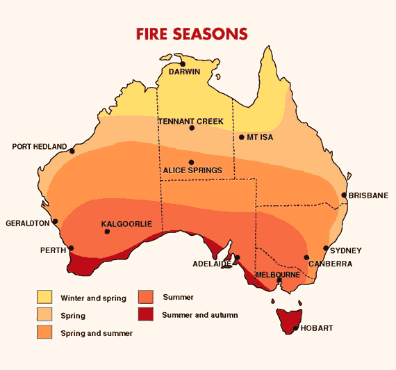
Image: fire seasons in different parts of Australia
What factors influence fire behaviour?
Weather-related factors that contribute to an increased risk of bushfire danger include:
- high temperatures;
- low humidity;
- little recent rain;
- abundant dry vegetation;
- strong winds; and
- thunderstorms.
When the weather is hot, humidity (moisture in the atmosphere) is low and there’s been little recent rain, vegetation dries out and becomes more flammable. Periods of wet weather can encourage vegetation growth, increasing the amount of fuel available—and future bushfire risk, if dry weather follows.
Strong, gusty winds help fan flames and will cause a fire to spread faster across the landscape, reducing the time you have to prepare.
Above the fire, strong winds can carry hot embers long distances. These can start ‘spot’ fires many kilometres ahead of the main fire front.
A change in wind direction can bring a dangerous period of bushfire activity. This is often seen as a trough or cold front (also known as a cool change) shifting the direction of the wind, altering the course of the fire and broadening the fire front.
Lightning, produced by thunderstorms, can ignite bushfires. Large fires can also create their own thunderstorms. These are known as pyrocumulonimbus, and are caused by the heat of the fire forcing the smoke and hot air above it to rise to the point where it cools and condenses into water droplets, eventually forming large clouds. Pyrocumulonimbus can cause erratic, more intense and dangerous bushfire behaviour, including lightning strikes that can cause new fires.
Fire warnings
The Bureau issues fire weather warnings when forecast weather conditions are likely to be dangerous. We work closely with emergency services around the country to keep the community informed.
The Bureau and emergency services use six fire danger ratings to communicate the level of bushfire risk. These ratings help the community know when to put their bushfire survival plan into action.
These ratings are: Low–Moderate, High, Very High, Severe, Extreme and Catastrophic (or Code Red in Victoria). The higher the rating, the more dangerous the conditions are likely to be, and at higher ratings any fire that starts will likely be fast-moving and difficult to control.
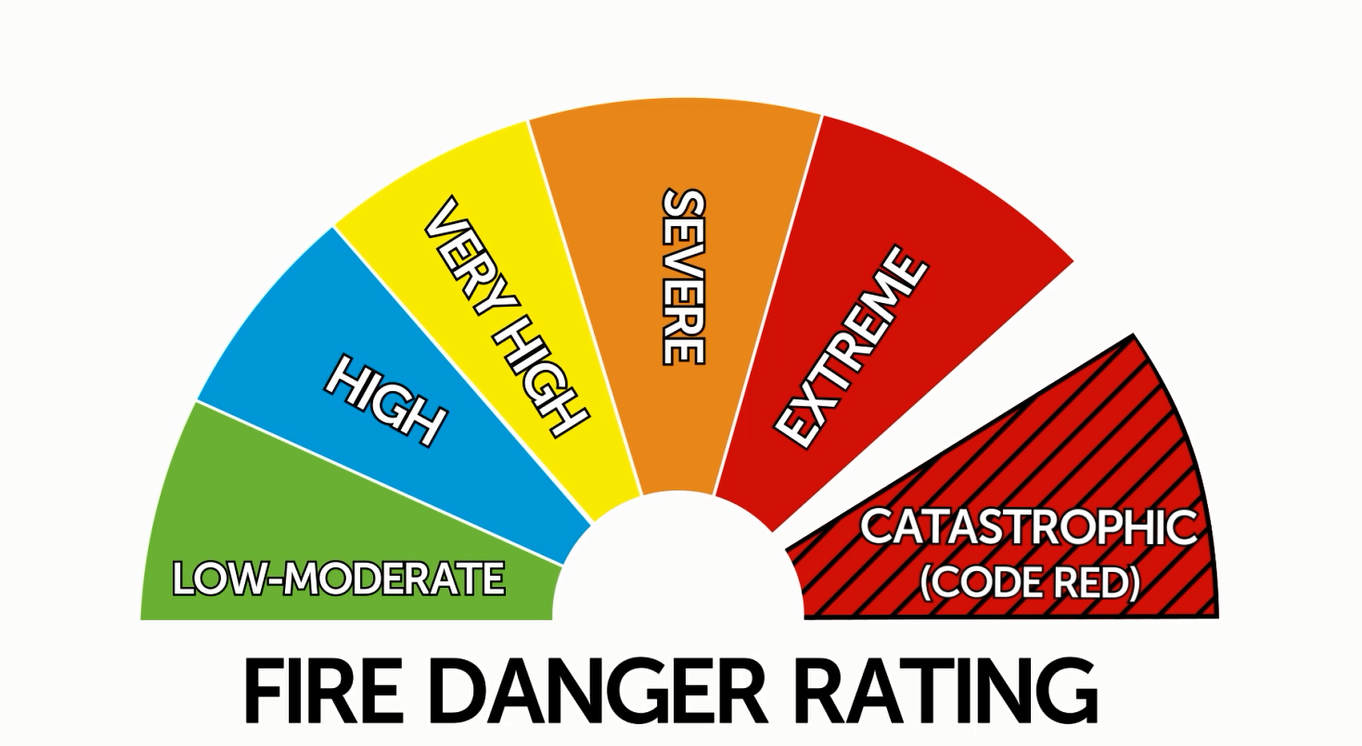
Image: Fire danger ratings used in Australia
What to do when there’s a risk of fire
No matter what the forecast fire rating, if you live in or are travelling to an area that could be threatened by fire, you need to have a bushfire plan in place, so you know what to do if a bushfire starts. On a day when dangerous bushfire activity is more likely, stay in touch with your local fire agency and emergency services via their websites and social media—and tune into emergency broadcasters.
More information
- Fire weather warnings
- Access all current warnings on our website (select your State or Territory and ‘View the current warnings’) or the BOM Weather app (tap the yellow triangle with the exclamation mark). You can also follow your State/Territory’s handle on Twitter.
- Bushfire weather
- Research: how mountain waves can escalate bushfires